
The plan is to get to Murgab today. It’s about 180 kms from Langar and last night we camped about 20 kms short of Langar. So around 200kms. Once we reach Langar the road starts to climb dramatically in a series of very narrow hairpins. No barriers and a long decent! The scenery becomes very barren and the valley widens out. We are surrounded by arid, brown, rocky peaks on both sides, but along side the track there are pink borders. Tiny thistles in bloom. No more than a few inches high. Where there are springs and streams their are also pink and white wild roses. So not completely barren. Soon it becomes more like a moonscape. Nothing but rocks and the distant peaks.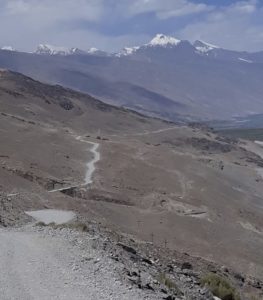
We see very few vehicles on the road. The occasional rental 4×4 with a local driver and tourists from somewhere. They don’t even slow down. There were a few motor cyclists who waved as they passed. We did stop and chat to a couple of cyclists. First we met Latvian, Valera, then a bit later a Swiss guy, Francois. They were both resting. To cycle at this altitude and on this surface you have to be crazy. It is not far off 4000 m and later in the day we crossed the Kargash Pass which is 4344 m. Shortly before the pass is the Kargash check point. Once again we have to have our passport and visa details hand written in a book.
Today we have passed our first yurts and also saw across the valley from us, 4 Afghans all dressed in black with coloured turbans and riding yaks.
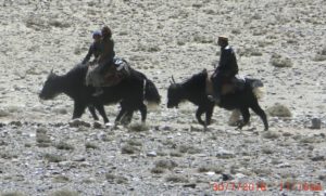
Afghan’s on Yaks. Taliban?
As we get closer to Murgab we see a large herd of yaks with their Kyrgyz herdsmen.
In the afternoon we see lots of chubby “critters”. We try to photograph them to be able to identify them later – when we eventually get some wifi. Not easy. As soon as they see us they hot foot it into a big communal burrow. They are a gingery/red colour with bushy tails, tipped with black. They look a bit like a hairy beaver. Tajik possums perhaps?
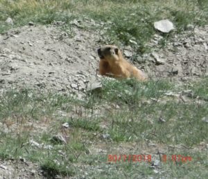
Tajik Possums?
We leave the Wakhan Valley and are back on the M41. It is sealed and reasonable in places, but it’s never continuous. You just get up speed and then the pot holes start. Progress is pretty good and we get to Murgab just after 4pm. What a S..t hole. Lonely Planet says it isn’t attractive, but that’s being kind. It feels like the last place on earth. Mud walled houses with flat roofs and telegraph/electric poles all over the place. We had hoped to find some more fruit and veg. but the only shop we could find had a minimal selection. Just onions and potatoes and shelves full of dry biscuits, sweets and a few tins and jars. Fortunately, we were able to find some diesel though. There were a few signs advertising home stays, but we decided to press on.
This part of the country, the Gorno-Badakhshan Autonomous Oblast (GBAO) is very poor. After the break up of the Soviet Union in 1991, Tajikistan declared independence. What followed was a bloody civil war, as the different parties, clans and geographical regions could not agree. The GBAO was blockaded and famine was only prevented by aid received from the Aga Khan Foundation. The Swiss born Aga Khan is revered by the people of this area as Mowlana Hazar Imam – 49th in a direct line traced back to the prophet.
Now we are camped parallel to the road but way across the valley. It is a very wide, open valley lined by colourful peaks in either side. I feel a bit exposed. We are miles from any habitation, though, and there is hardly a car on the road. Hopefully, a good night’s sleep will follow. We can both feel the altitude, but it us not seriously affecting us.
Views: 43
From wild roses to sh!tholes all in one post – loving the imagery!
Well done to both you and the vehicle to get over those passes without completely running out of puff!